A page from Pegolotti’s “The Practice of Commerce” which contains the Ayas-Tabriz itinerary

Sinclair Lecture Reveals Interconnectedness of Medieval Armenia

1117
0

BELMONT, Mass. —  On Friday, March 4, the National Association for Armenian Studies and Research (NAASR) sponsored a lecture by Dr. Thomas Sinclair, formerly of the University of Cyprus.

Sinclair was a professor of Turkish history in the Department of Turkish and Middle Eastern Studies at the university. His most prominent achievement was the 4-volume work, Eastern Turkey: an Architectural and Archaeological Survey.

This monumental work, though not the subject of Friday’s lecture, is of enormous importance to Armenians, and deserves a brief explanation. This magnum opus details practically every historical and archaeological site in Eastern Turkey, including Roman/Byzantine, Seljuk, Ottoman, Syriac, Georgian and Armenian sites. The region surveyed includes Van, Mush, Kars, Ani, Tayk, Erzurum, Trebizond/Pontus, Yerzinga, Divrig, Sepastia, Tokat, Agn, Arabkir, Kharpert, Diyarbakir, Mardin, Tur Abdin, Urfa, Hromkla, Marash, Aintab, Kilis, Antioch, Iskenderun, and the surrounding areas.

Sinclair’s unbiased approach unsurprisingly reveals the deep Armenian roots of most of the regions he covers. The books, published in 1989-1990, are very dry and scholarly, but are invaluable for scholars and would probably be of great use as a reference work for any Armenian wishing to travel to the land of their ancestors and specifically locate important sites; for instance the tomb of St. Gregory the Illuminator, which is on a mountainside near the city of Erzincan (Yerzinga to Armenians); Sinclair having visited all these sites gives a sort of guide for backpackers down to the details of what footpath to take to get from one site to another. E-book editions seem to be available for more affordable prices.

Armenia: Crossroads of Trade Routes

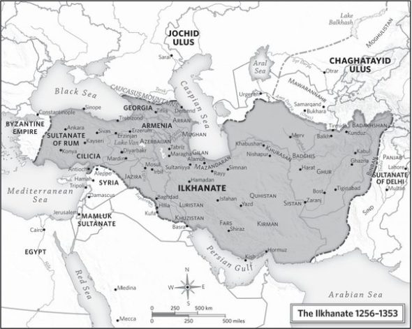
On Friday, March 4, Sinclair took a related topic as the subject of his lecture, namely the interconnectedness of the cities of Medieval Armenia on East-West trade routes. Specifically, he covered the subject matter of his latest book, Eastern Trade and the Mediterranean in the Middle Ages: Pegolotti’s Ayas-Tabriz Itinerary and its Commercial Context. The book analyzes the itinerary (an ancient and medieval type of travel guide which led you on specific route, giving you all the important stops on the way) written in the 14th century about the route from Ayas in Cilician Armenia to Tabriz in Persia, by one Francesco Balducci Pegolotti, a merchant from Florence who worked for the Compagnia dei Bardi, a Florentine bank.

Get the Mirror in your inbox:

It would seem that Armenia’s position at the “crossroads” of East and West is something that many Armenians don’t truly understand. For one thing, it is a part of Armenian history that involves merchants and businessmen, not brave heroes. For another, Armenia’s status as a trade nexus no longer exists in large part; Armenia’s location in today’s geopolitical world causes the country to struggle, not thrive. On the other hand, as Sinclair’s lecture teaches us, political events can also drastically change the flow of trade, and the current war in Ukraine is already having some interesting effects, the outcome of which remain to be seen.

Sinclair began his lecture by discussing the history of the East-West trade route. Most Western schoolchildren at some point are taught that there was once something known as the “overland route” to China and “the Indies;” they learn this route was difficult, and that’s why Columbus tried sailing west to get to the East. Few of us, including those of Armenian descent, seem to know the details of such a route. We might know that Marco Polo travelled that route. But do we know that Marco Polo went through Armenia? And do we know that not only Marco Polo, but multitudes of merchants and travelers went through Armenia?

Sinclair, using the “Pegolotti Itinerary” as a starting point, focused on trade in the region during the period of the Il-Khanate. The Il-Khanate was an empire the originated when Hulagu, grandson of Genghis Khan, inherited the Middle Eastern portion of the Mongol Empire upon the death of his brother, Möngke Khan, in 1259. The Empire’s capital was at Tabriz, and the Mongol rulers, who eventually converted to Islam, presented themselves as the heirs to the monarchy of ancient Persia, ruling over a vast region that also included Historic Armenia.

Northwestern Armenia had still been under the rule of the Seljuks in Western Asia Minor during the early 1200s, Sinclair related. Then the Mongol Empire took over, immediately succeeded in the region by the Il-Khanate. Before the Mongol conquest, the primary route from Europe to East Asia was a southerly one that passed through Syria and northern Mesopotamia. When the Mongols raided Upper Mesopotamia, and today’s Syrian-Iraqi region was further destabilized by continuous warfare between the Mongols and the Mamluks (a caste of Turkish speaking former slave warriors who ruled Egypt and Syria), the southerly route became unusable and East-West trade had to proceed elsewhere.

The new route passed through Cilicia and Historic Armenia. In broad terms, the Mediterranean port of Ayas (adjacent to Adana in Cilician Armenia) was the embarkation point for ships from Europe; merchants then went overland through Sivas (Sepastia), Erzurum (Garin), and reached Tabriz, the primary commercial center and capital of the Il-Khanate.

The Pegolotti Itinerary is a guide for merchants describing the route taken from Ayas in Cilician Armenia to Tabriz in Persia. Various tolls had to be paid by the merchants along the way. Although the Pegolotti Itinerary was written in Florentine Italian and apparently intended for the information of European traders, most of the merchants on the route would have been locals, mainly Armenians, says Sinclair. This route was in use throughout the Il-Khanate period, which lasted until the Black Plague of the 1330s, and apparently ended when the Mamluks conquered Ayas from the Armenians in 1337, which was incidentally around the time that Pegolotti wrote his book.

Deciphering a Medieval Text

According to Sinclair, the major difficultly with using this itinerary to establish the trade route is that the names are extremely distorted. Sometimes they are even based on place names given in earlier Roman-era travel guides, and in all cases, they have been Italianized. Another problem is that there are no distances given in the guide. Nevertheless, Sinclair has tried to reconstruct Pegolotti’s route.

Sinclair took the listeners on a journey through the route. The trip starts in Ayas, a port city on the Mediterranean which was built up during the Armenian Kingdom of Cilicia.

The next stop was the present-day town of Kadirli, referred to as “Colidara” by Pegolotti. This was a walled city that dated back to the Roman era. The toll to paid there was four times as much as normal, because one was leaving Armenian Cilicia and entering Mongol-ruled territory.

The route passed through the Taurus mountains in the northern part of Cilicia (rather than the “Cilician Gates” to the west) and arrived at Gandon (Roman-era Comana and modern day Şar.) From there the route stopped at several Seljuk-era caravanserais in the area between Kayseri (Armenian Gesaria, which the route bypassed) and the next major destination of Sivas.

Sivas, known to Armenians as Sepastia, was referred to by Pegolotti as “Salvastro.” According to Sinclair, though there was a large Armenian community there, at the time they only had one church in the city, and the Monastery of the Holy Sign (Soorp Nshan) to the south of the city center. The Seljuks had made a tremendous investment in building projects such as madrassas and mosques, which are still standing; the Armenian churches, of which there were over five by the late Ottoman period, are no more.

The route passed east through the valley of the Kizilirmak (Armenian: Alis, Classical Greek: Halys) mentioning a place called “Dudriaga” (the Armenian village of Todorag), and then up into the “yayla” (upland plain) where the Alis River begins, from whence the route goes north through the mountains into the valley of the Kelkit Çay (a Turkish name derived from the Armenian “Kayl Ked” or Wolf River). The next stop was a town in that valley known to the Greeks and Romans as Nicopolis, but which Pegolotti called “Greboco”. Sinclair explained that the Armenians called this place “Aghpiurk” (springs) which is where “Greboco” comes from, and that the modern Turkish name of the village, “Pürk” is derived from the Armenian.

The road continued through relatively easy country in the Sushehri Valley, but while the modern road continues due east from there, in Pegolotti’s time this was difficult and “savage” country, and so he diverged, travelling south through the mountains to Kemakh, which he referred to as “Mughisar.” This was a fortress built on the cliffs high above the valley of the Upper Euphrates.

The next stage of the journey took the path of an old Roman road, built, according to Sinclair, when Rome first acquired Armenia (in the late 4th century AD). The Romans later pulled out of the region, and the road was forgotten, but the obvious traces of a paved road still exist. The road leads from Kemakh to Erzincan (Yerzinga in Armenian), which Pegolotti called “Eriza.” This was the “most Armenian” of the cities thus far, according to Sinclair. Its layout was originally a grid in the Roman style; it had markets, churches, monasteries, and was full of Armenian merchants, according to a Spanish source.

After Erzincan, the path follows the Upper Euphrates. The path crosses a bridge and passes through the village of Pagarich before getting to the Plain of Erzurum.

Dr. Thomas Sinclair, University of Cyprus

Despite the fact that Erzurum was a thriving city and was at the intersection of the Ayas-Tabriz trade route and was even visited by Marco Polo, there is some mystery surrounding it in the available texts. Sinclair attributes Erzurum’s unclear status to the fact that the Il-Khans did not always have control over the city.

The route then goes eastward through the plains and south through mountains to an upland plain, which seems to be a detour. Again, this was done because the more “direct route” (as the crow flies) went through mountains that were more difficult to pass. In this small, sparsely populated area there were two toll stations mentioned by Pegolotti.

Continuing through that region the route returns from its “detour” to the regular line described in the Roman itineraries, which takes the traveler to the Plain of Alashkert. The route stops at a place Pegolotti called “Calacresti” (Karakilise, the modern Agri, which is the market town of the area), and passes through the plains on the southwest side of Mt. Ararat, which Pegolotti calls “Sotto l’Arcanoe” (“Beneath the Ark of Noah”). The route then progresses easily through a series of plains to Khoy and then Tabriz.

The city of Tabriz had witnessed an extraordinary expansion in this period. A new city wall was built under the IlKhanids to accommodate the expansion. There were five main gates, and inside each there was a caravanserai, a shopping complex and a hamam (public bath). Tabriz had relatively large communities of Genoese and Venetians merchants as well as those of four other Italian cities. There was an Armenian element, and also a Nestorian element.

Map of the Ilkhanate, showing Armenian Cilicia as part of the empire, as well as Sivas, Erzinjan, Erzurum, and Tabriz

Conclusion

Sinclair drew various conclusions from his analysis. The route was chosen not for directness but for ease of travel, although it does go through commercial centers. The impact on cities was immense, particularly Sivas and Ayas which were boom towns in this period. Finally, he mentions that the “Ayas Road” was actually one of the most important, if not the most important of its time.

There were other East-West routes such as the one through Trebizond, which was not as popular. There were two major ports on the Black Sea, Caffa (in Crimea) and Tana, which led to a northerly route through the Eurasian Steppe to China. That route sustained some large cities, and was important because of the slave trade of the time. Slaves were captured in today’s Ukraine and sold in the Mamluk Kingdom of Egypt (whose ruling class were also composed of former slaves). There was also the route going from Egypt through the Red Sea to India and the East, which was commonly used for the spice trade, but it didn’t have as high of a volume. Therefore, the Ayas route stands out among the others.

Sinclair also mentioned that the use of silver currency increased at this time, because the items being sent from Asia, though lighter and easier to carry, were of higher value (i.e. spices, silk) than what was exported from Europe (i.e. iron, soap). Silver currency was needed to make up the monetary difference, which required a flow of silver to Ayas.

There were various changes in the trade routes that took place thanks to political fluctuations and warfare. For instance, prior to the Cilician period, trade went from Sivas north to the Black Sea at Sinop. Although the Trebizond connection was important at the time of Pegolotti, later it was superseded by Bursa, which is closer to Istanbul. The route through Aleppo from Upper Mesopotamia was almost forgotten until the city revived in the late 1400s, and so on.

Sinclair stated that the study of these trade routes and medieval geography is also the study of society at that time. The nature of money was different, and the nature of travel was different, he stated, and by understanding cities and roads, one can understand its society.

To purchase a copy of Eastern Trade and the Mediterranean in the Middle Ages: Pegolotti’s Ayas-Tabriz Itinerary and its Commercial Context by Sinclair visit amazon or routledge.com.

Get the Mirror-Spectator Weekly in your inbox: