


YEREVAN — Armenian governmental bodies have yet to define the exact territories on which the military activities of the prior week took place. Cartographer Shahen Shahinyan, founder of the Armenian electronic mapping project ELMA [“Electronic Map”] and former head of the Scientific and Technological Department of the Armenian nonprofit called Geodesy and Cartography [Geodezia yev Kartezagrutyun] provides some clarifications on this topic, as he has studied the area through satellite imagery.
“According to the information that I have, no changes in positions have taken place. The information spread by the Ministry of Defense about the loss of two positions must [therefore] be seen in a different light. Those positions were right on the border line because the [Azerbaijani] troops who attempted to advance were partially annihilated by our artillery and guards holding positions, while the others withdrew,” Shahinyan said.
“The published videos in which the advance of Azerbaijani forces and equipment appear depict the valley area between Ishkhanasar and Tsitsernakar,” he stated, specifying: “Of course, clashes also took place in the Tsghut sector, which is a part of the Black Lake (Sev Lich) area; further north, in the Tsitsernakar area; and in the northern sector, which is a part of the Black Lake area too, where the Armenian and Azerbaijani positions are only 10-50 meters distant from one another. There could have been local fights there, but the artillery battles took place chiefly to the south of Tsitsernakar and to the north and northwest of the Mets Ishkhanasar massif.”
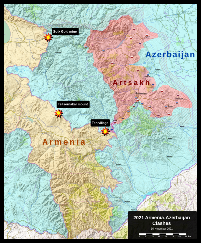
“There was fighting similarly at the foot of Mets Ishkhanasar, but as their positions were on higher ground, and it appears in videos that they are coming to a flat area, it must be concluded that the fighting took place at the foot of Iskhanasar towards the flat area to the north and northwest, which is Armenian land,” said the expert.
Shahinyan also commented on the border demarcation efforts and maps of the Soviet era which are preserved at the Russian army’s General Staff. He said, “There are very old maps in Russia and those are more useful for us. Our research testifies to that. There is proof that in 1925-26, Armenia’s territory was larger, comprising up to 30,000-31,000 square kilometers, which afterwards was continually reduced. The vivid proof of that is in the Soviet encyclopedias. In the first edition, Armenia’s territory is large; in the second, smaller; and in the third, it is the expanse which composed Soviet Armenia in its last years, in the 1980s. In the speech [by Pashinyan] that ‘there must be compromises and exchanges of territories,’ the reference most likely is to the maps of the 1970s. Naturally, in order to have definitive answers, it is necessary to study all existing materials. Territorial enclaves already exist in the maps of the 1970s. And after this, in two editions of the Soviet Encyclopedia, they are already set.”
He concluded, “If demarcation and delimitation were conducted according to the maps of the 1970s and without in-depth analysis, not taking into consideration the economic, legal and political consequences but conducted on the level of a dilettante blindly looking at the maps, then three ‘enclave territories,’ two of them in Tavush and one in Ararat Province, would be transferred to Azerbaijan, Artsvashen would be returned to Armenia, and as just one part of the Kapan-Goris road has passed under Azerbaijani control, a portion of the border road with Georgia from Noyemberyan would be transferred in the same way, since that road several times crosses the frontier.”


