Dr. Adam T. Smith of Cornell

ITHACA, N.Y. —  Ever since the beginning of last year’s war, one thing on the minds of most Armenians in the homeland and Diaspora, aside from the loss of life and territory, has been the fate of Armenian heritage sites — churches, monasteries, monuments, and so on — in the region of Nagorno-Karabakh. It’s not just the Armenian community and the Republics of Armenia and Artsakh that are concerned. The scholarly community is too, and quite rightly. They have seen the destruction to which Armenian monuments have been subjected in Turkey, Nakhichevan, and elsewhere.

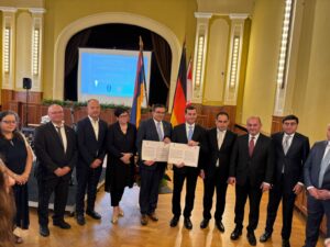
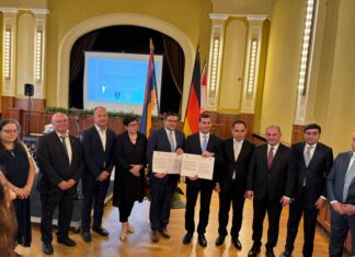
Based at Cornell University, a group called Caucasus Heritage Watch has stepped into the fray with a goal to protect heritage sites under threat due to Azerbaijan’s territorial gains.

A Veteran Team Handles a New Challenge

Archaeologists Lori Khatchadourian and Adam T. Smith of Cornell, and Ian Lindsay of Purdue have been working together since 2002 on the longest-running international project in the South Caucasus, digging around the northern and eastern slopes of Mt. Aragats. (Smith himself has been working in Armenia since 1992.) The team had been working with local archaeologists from Armenia as well where, according to Smith, there is “terrific talent.”

The loss of territory to Azerbaijan shifted the scholars’ attention eastward to the Artsakh region. According to Smith, they had been “watching the aftermath [of the war], having known what has happened to heritage monuments elsewhere, that there was a real present danger and threat. And we had the skills and tools to use satellite technology to monitor sites.”

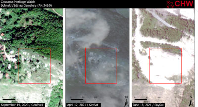
Like many archaeologists, the group had been using satellite imagery for years. Initially it was in the form of photos released from the NASA archives. Smith and his team were using these photos to detect long-term landscape change, as well as locating sites that would be hard to find on foot. In recent years, private companies have also tapped into that bandwidth, providing pictures for a fee. Smith’s group has been working with a company called Planet Labs to get satellite images of the areas in Armenia where they were digging. From Planet Labs, they have been able to order images of specific places at specific times. Now they needed to use those resources for a different goal.

Dr. Lori Khatchadourian

Get the Mirror in your inbox:

Eyes On Artsakh

The first task was to compile a database of all heritage sites in the Karabakh region. “We spent a huge amount of time putting together the database just to know where the sites were and what the level of risk was,” says Smith. That job took from December 2020 through March 2021, and the database is still growing.

The second step was tasking satellites to make sure there was maximum visibility. The evaluations take place at Cornell and Purdue, Smith says. “We look at the images side by side, so we have a pretty significant compendium we can draw on to look for damage, destruction, and threat.”

Two areas of immediate threat are the historic city of Shushi, and anywhere roads are being constructed. The team has been tracking the movements of Azeri road construction crews and has seen that cemeteries are disappearing in their wake. Since there has been no permission from UNESCO or another organization to go to the region directly and inspect these sites, satellite technology turns out to be the best option for gathering information about the facts on the ground in Karabakh.

An Unprecedented Project

The public response to the project has been “amazing” says Smith. “There is a lot of engagement.” With more than 1,000 followers on Twitter, Caucasus Heritage Watch is quite popular for an archaeological platform.

There is not a lot of precedence for a non-state actor trying to affect state policy, certainly not in relation to heritage sites, Smith said. Sadly, the destruction of monuments and cultural heritage is not new. One of the most notable cases was the destruction of Buddhist statues in Bamiyan, Afghanistan in 2001 by the Taliban insurgents. In addition, vital work was done with satellite imagery to surveil areas of Syria and Northern Iraq when it was under ISIS control. But the group working on that project wasn’t dealing with a recognized state actor like Azerbaijan, or even attempting to create deterrence. Furthermore, they were reliant on government-contract satellite imagery shared with them by the US.

Satellite Imagery Showing Sghnakh Armenian Cemetery Destroyed

Smith, Khatchadourian, Lindsay, and the other team members, Salpi Bocchieriyan and Dr. Husik Ghulyan, have their work cut out for them. “I think this is a long-term project,” Smith said. “It will probably go on for 8 to 10 years,” implying that this is how long it would take Azerbaijan to destroy all the monuments in Karabakh, with a few left over to be branded as “Caucasian Albanian.”

“We hope that our work can be some level of deterrent,” noted Smith. With knowledge of what is happening — documented in real time — diffused not only through the Armenian community, but also the world, Smith and his colleagues hope that negative press can deter Azerbaijan from continuing their destruction. If not, at least there will be a record of what happened and how it happened, documented by an unbiased, professional, and scholarly organization.

The website of Caucasus Heritage Watch can be accessed at https://caucasusheritage.cornell.edu/index.php/home.

CHW’s Twitter account is @CaucasusHeritageWatch

Get the Mirror-Spectator Weekly in your inbox: